
Contents
- 🌊 Introduction to Ocean Mapping
- 📊 The Science of Bathymetry
- 🌴 Applications of Bathymetry
- 🚣♀️ History of Bathymetry
- 📈 Advances in Bathymetric Technology
- 🌊 Marine Life and Ecosystems
- 🌟 Coastal Analysis and Dynamics
- 🚨 Predicting Currents and Tides
- 🌎 Global Efforts in Ocean Mapping
- 👥 Key Players in Ocean Mapping
- 🔍 Challenges and Future Directions
- 📊 Conclusion and Future Prospects
- Frequently Asked Questions
- Related Topics
Overview
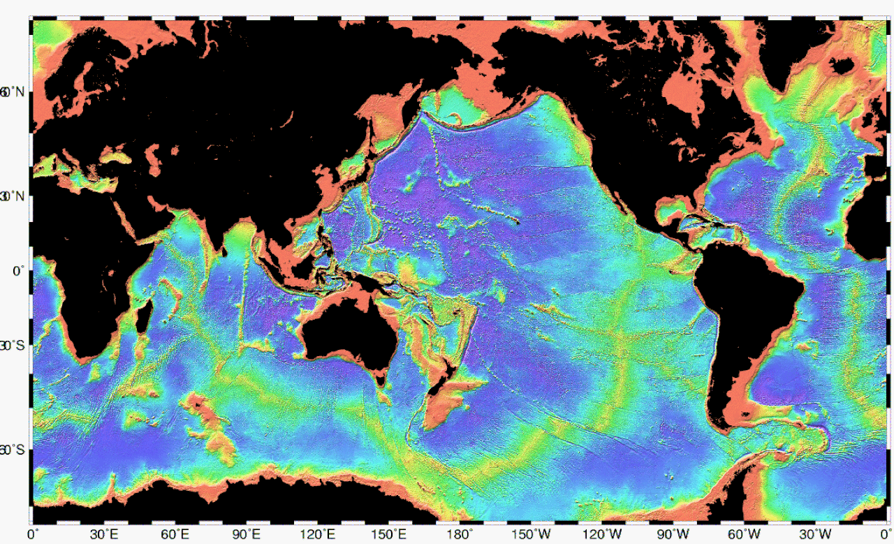
Ocean mapping, with a vibe score of 8, has evolved significantly from its inception, with early cartographers like Gerardus Mercator (1512-1594) laying the groundwork. Today, advanced sonar technologies and autonomous underwater vehicles (AUVs) are being employed by organizations like the General Bathymetric Chart of the Oceans (GEBCO) to create high-resolution maps of the seafloor. The controversy surrounding the economic and environmental implications of deep-sea mining has sparked heated debates, with some arguing it could lead to unprecedented wealth and others claiming it may cause irreparable damage. As of 2022, only about 15% of the ocean floor has been mapped, leaving a vast, unexplored territory. The influence of key figures like Dr. Robert Ballard, who discovered the Titanic wreck in 1985, has propelled the field forward. With the increasing availability of satellite data and AI-powered analysis tools, the future of ocean mapping looks promising, but the challenge of balancing exploration with conservation remains a pressing concern.
🌊 Introduction to Ocean Mapping
The world of ocean mapping is a fascinating and complex field that has been evolving for thousands of years. The study of underwater depth, also known as bathymetry, is crucial for understanding our oceans and the creatures that inhabit them. Oceanography is the broader field that encompasses bathymetry, and it has led to numerous discoveries and a deeper understanding of our planet. The first recorded evidence of water depth measurements dates back to Ancient Egypt over 3000 years ago, highlighting the importance of this field in human history. Today, bathymetric charts are used to guide vessels and identify underwater hazards, making them an essential tool for marine navigation.
📊 The Science of Bathymetry
Bathymetry is the underwater equivalent to hypometry or topography, and it has various uses beyond just navigation. The study of marine life near the floor of water bodies, known as benthic ecology, relies heavily on bathymetric data. Coastline analysis and ocean dynamics are also critical applications of bathymetry, as they help us understand and predict currents and tides. By studying the shape and features of the ocean floor, scientists can gain insights into the Earth's history and the processes that shape our planet. Geology and geomorphology are closely related fields that also benefit from bathymetric research.
🌴 Applications of Bathymetry
The applications of bathymetry are diverse and far-reaching. In addition to navigation and marine life studies, bathymetry is used in offshore engineering, coastal management, and ocean conservation. Bathymetric surveying is a crucial step in the development of offshore wind farms and other coastal infrastructure projects. By understanding the shape and features of the ocean floor, scientists and engineers can design more efficient and sustainable systems. Renewable energy sources, such as tidal and wave power, also rely on accurate bathymetric data to optimize their performance.
🚣♀️ History of Bathymetry
The history of bathymetry is a long and fascinating one, with evidence of water depth measurements dating back to Ancient Civilizations. The first recorded evidence of bathymetry comes from Ancient Egypt, where it was used for navigation and fishing. The ancient Greeks also made significant contributions to the field, with Aristotle and Eratosthenes conducting early studies of the ocean floor. The development of sonar and submarine technology in the 20th century revolutionized the field of bathymetry, enabling scientists to map the ocean floor with greater accuracy and precision. Ocean exploration has come a long way since then, with remote operated vehicles and autonomous underwater vehicles playing a crucial role in modern bathymetric research.
📈 Advances in Bathymetric Technology
Advances in bathymetric technology have been rapid and significant in recent years. The development of lidar and multibeam sonar has enabled scientists to create highly detailed and accurate maps of the ocean floor. Satellite imagery and airborne lidar have also become essential tools in bathymetric research, allowing scientists to study the ocean floor over large areas. Artificial intelligence and machine learning are being used to analyze and interpret the vast amounts of data generated by these technologies, leading to new insights and discoveries. Data visualization is also playing a crucial role in communicating the results of bathymetric research to the public and stakeholders.
🌊 Marine Life and Ecosystems
Marine life and ecosystems are closely tied to the shape and features of the ocean floor. Coral reefs, for example, are found in shallow, tropical waters and are home to a vast array of marine species. Deep-sea ecosystems are found in the deepest parts of the ocean and are characterized by unique and often bizarre creatures. Benthic ecology is the study of these ecosystems and the creatures that inhabit them, and it relies heavily on bathymetric data. By understanding the shape and features of the ocean floor, scientists can gain insights into the distribution and abundance of marine species. Marine conservation efforts also rely on accurate bathymetric data to identify and protect critical habitats.
🌟 Coastal Analysis and Dynamics
Coastal analysis and dynamics are critical applications of bathymetry. By studying the shape and features of the ocean floor, scientists can understand and predict coastal erosion and coastal accretion. Coastal management is a complex and multidisciplinary field that relies on bathymetric data to make informed decisions about coastal development and conservation. Ocean dynamics are also closely tied to the shape and features of the ocean floor, and bathymetry plays a critical role in understanding and predicting currents and tides. Climate change is also having a significant impact on coastal ecosystems and dynamics, and bathymetry is essential for understanding and mitigating these effects.
🚨 Predicting Currents and Tides
Predicting currents and tides is a critical application of bathymetry. By understanding the shape and features of the ocean floor, scientists can model and predict the movement of water in the ocean. Ocean modeling is a complex and multidisciplinary field that relies on bathymetric data to make accurate predictions. Tide prediction is also a critical application of bathymetry, as it is essential for navigation and coastal management. Current prediction is also important for understanding and predicting the movement of marine species and the transport of nutrients and pollutants. Ocean forecasting is a rapidly evolving field that relies on bathymetric data to make accurate predictions about ocean conditions.
🌎 Global Efforts in Ocean Mapping
Global efforts in ocean mapping are underway to create a comprehensive and accurate map of the ocean floor. The General Bathymetric Chart of the Oceans (GEBCO) is a international project that aims to create a comprehensive and accurate map of the ocean floor. National Oceanic and Atmospheric Administration (NOAA) is also playing a critical role in ocean mapping, with a focus on coastal mapping and marine conservation. International Hydrographic Organization (IHO) is also involved in ocean mapping, with a focus on hydrography and nautical charts.
👥 Key Players in Ocean Mapping
Key players in ocean mapping include National Geographic, Woods Hole Oceanographic Institution, and University of California. These organizations are working together to advance our understanding of the ocean and to create a comprehensive and accurate map of the ocean floor. Ocean exploration is a complex and multidisciplinary field that requires collaboration and cooperation between scientists, engineers, and policymakers. Marine policy is also critical for ensuring that ocean mapping is used to benefit society and the environment.
🔍 Challenges and Future Directions
Challenges and future directions in ocean mapping include the need for more accurate and comprehensive data, as well as the development of new technologies and methods for collecting and analyzing data. Artificial intelligence and machine learning are being used to analyze and interpret the vast amounts of data generated by ocean mapping, leading to new insights and discoveries. Data visualization is also playing a crucial role in communicating the results of ocean mapping to the public and stakeholders. Ocean governance is also critical for ensuring that ocean mapping is used to benefit society and the environment.
📊 Conclusion and Future Prospects
In conclusion, ocean mapping is a complex and multidisciplinary field that has the potential to revolutionize our understanding of the ocean and its role in the Earth's system. By advancing our understanding of the ocean floor and its features, we can better manage and conserve marine ecosystems, predict and mitigate the effects of climate change, and ensure the long-term sustainability of our planet. Ocean mapping is a critical component of ocean conservation and sustainable development, and it requires continued investment and support from governments, organizations, and individuals around the world.
Key Facts
- Year
- 2022
- Origin
- Ancient Civilizations
- Category
- Environmental Science
- Type
- Scientific Field
Frequently Asked Questions
What is bathymetry?
Bathymetry is the study of underwater depth of ocean floors, river floors, or lake floors. It is the underwater equivalent to hypsometry or topography. Bathymetry has various uses including the production of bathymetric charts to guide vessels and identify underwater hazards, the study of marine life near the floor of water bodies, coastline analysis and ocean dynamics, including predicting currents and tides.
What are the applications of bathymetry?
The applications of bathymetry are diverse and far-reaching. In addition to navigation and marine life studies, bathymetry is used in offshore engineering, coastal management, and ocean conservation. Bathymetric surveying is a crucial step in the development of offshore wind farms and other coastal infrastructure projects.
What is the history of bathymetry?
The history of bathymetry is a long and fascinating one, with evidence of water depth measurements dating back to Ancient Civilizations. The first recorded evidence of bathymetry comes from Ancient Egypt, where it was used for navigation and fishing. The ancient Greeks also made significant contributions to the field, with Aristotle and Eratosthenes conducting early studies of the ocean floor.
What are the challenges and future directions in ocean mapping?
Challenges and future directions in ocean mapping include the need for more accurate and comprehensive data, as well as the development of new technologies and methods for collecting and analyzing data. Artificial intelligence and machine learning are being used to analyze and interpret the vast amounts of data generated by ocean mapping, leading to new insights and discoveries.
What is the importance of ocean mapping?
Ocean mapping is a critical component of ocean conservation and sustainable development. By advancing our understanding of the ocean floor and its features, we can better manage and conserve marine ecosystems, predict and mitigate the effects of climate change, and ensure the long-term sustainability of our planet.