
Contents
- 🌎 Introduction to Geospatial Intelligence
- 📸 Imagery and Imagery Intelligence (IMINT)
- 📍 Geospatial Information and Mapping
- 📊 Analysis and Exploitation of Geospatial Data
- 🚀 Remote Sensing and Satellite Technology
- 🤝 Collaboration and Partnerships in GEOINT
- 🔍 Applications of Geospatial Intelligence
- 🚫 Challenges and Limitations of GEOINT
- 📈 Future of Geospatial Intelligence
- 📊 Geospatial Intelligence in the US Code
- 🌐 Global Geospatial Intelligence Community
- Frequently Asked Questions
- Related Topics
Overview
Geospatial intelligence (GEOINT) is a rapidly evolving field that combines geographic information systems (GIS), remote sensing, and spatial analysis to support national security, disaster response, and environmental monitoring. With the increasing availability of satellite and drone imagery, GEOINT has become a critical component of modern intelligence gathering, allowing analysts to track changes in the physical environment and identify potential security threats. The field has a rich history, dating back to the Cold War era, when the US military first began using satellite imagery to gather intelligence on Soviet military activities. Today, GEOINT is used by a wide range of organizations, from government agencies to private companies, to analyze and understand complex geospatial phenomena, such as climate change, urbanization, and global supply chains. As the field continues to advance, it is likely to play an increasingly important role in shaping global events and informing decision-making at the highest levels. With a vibe score of 8, GEOINT is an exciting and dynamic field that is full of possibilities and challenges, from the use of artificial intelligence and machine learning to the integration of emerging technologies like the Internet of Things (IoT) and autonomous systems.
🌎 Introduction to Geospatial Intelligence
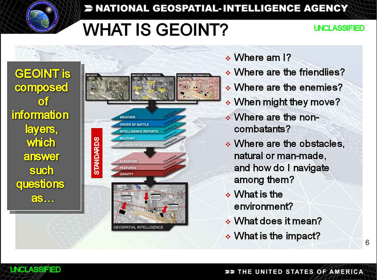
Geospatial intelligence (GEOINT) is a crucial component of modern intelligence gathering, providing critical information about human activity on Earth. As defined in the US Code, GEOINT consists of imagery, imagery intelligence (IMINT), and geospatial information. The field of GEOINT has evolved significantly over the years, with advancements in remote sensing and satellite technology enabling the collection and analysis of vast amounts of geospatial data. For instance, the National Geospatial-Intelligence Agency (NGA) plays a vital role in supporting national security and defense missions. The GEOINT Foundation also provides valuable resources and support for the geospatial intelligence community.
📸 Imagery and Imagery Intelligence (IMINT)
Imagery and imagery intelligence (IMINT) are essential components of GEOINT. Imagery refers to the visual representation of objects or areas, while IMINT involves the analysis and interpretation of these images to extract meaningful information. The use of unmanned aerial vehicles (UAVs) and satellite imagery has revolutionized the field of IMINT, enabling the collection of high-resolution images and video footage. For example, the Lockheed Martin company has developed advanced UAV systems for surveillance and reconnaissance missions. The DigitalGlobe platform also provides access to high-resolution satellite imagery for various applications.
📍 Geospatial Information and Mapping
Geospatial information and mapping are critical aspects of GEOINT. Geospatial information refers to the data associated with geographic locations, such as latitude, longitude, and elevation. This information is used to create detailed maps and models of the environment, which can be used to support a range of applications, from urban planning to disaster response. The ESRI company is a leading provider of geographic information system (GIS)) software and solutions. The OpenStreetMap project also enables collaborative mapping and data sharing for various applications.
📊 Analysis and Exploitation of Geospatial Data
The analysis and exploitation of geospatial data are essential steps in the GEOINT process. This involves using specialized software and techniques to extract meaningful information from large datasets, such as satellite imagery and sensor data. The use of machine learning and artificial intelligence (AI) is becoming increasingly important in this field, as it enables the automation of many tasks and the identification of patterns and trends. For instance, the Google Earth platform provides a powerful tool for visualizing and analyzing geospatial data. The QGIS software also offers a free and open-source alternative for geospatial data analysis.
🚀 Remote Sensing and Satellite Technology
Remote sensing and satellite technology have revolutionized the field of GEOINT. Remote sensing involves the collection of data about the environment using sensors and other technologies, while satellite technology enables the transmission and reception of this data. The use of synthetic aperture radar (SAR) and hyperspectral imagery has enabled the collection of high-resolution images and data, even in areas with limited visibility. The NASA agency has developed advanced satellite systems for Earth observation and remote sensing applications. The European Space Agency (ESA) also operates a range of satellite missions for Earth observation and other purposes.
🤝 Collaboration and Partnerships in GEOINT
Collaboration and partnerships are essential in the field of GEOINT. The GEOINT community is a global network of organizations and individuals working together to advance the field of geospatial intelligence. This includes government agencies, private companies, and academic institutions, all of which play a critical role in supporting national security and defense missions. For example, the US Geological Survey (USGS) works closely with other agencies to provide geospatial data and support for various applications. The NGA also partners with other organizations to advance the field of GEOINT.
🔍 Applications of Geospatial Intelligence
The applications of geospatial intelligence are diverse and widespread. GEOINT is used to support a range of activities, from national security and disaster response to urban planning and environmental monitoring. The use of GIS and remote sensing technologies has enabled the creation of detailed maps and models of the environment, which can be used to inform decision-making and support a range of applications. For instance, the FEMA agency uses geospatial intelligence to support disaster response and recovery efforts. The World Bank also uses geospatial data to support development projects and initiatives.
🚫 Challenges and Limitations of GEOINT
Despite the many advances in the field of GEOINT, there are still several challenges and limitations that must be addressed. These include the need for greater interoperability between different systems and technologies, as well as the requirement for more advanced data analytics and machine learning capabilities. The use of cloud computing and big data analytics is becoming increasingly important in this field, as it enables the processing and analysis of large datasets. The Amazon Web Services (AWS) platform provides a range of cloud-based services for geospatial data analysis and processing. The Microsoft Azure platform also offers a range of cloud-based services for geospatial data analysis and processing.
📈 Future of Geospatial Intelligence
The future of geospatial intelligence is likely to be shaped by a range of factors, including advances in remote sensing and satellite technology, as well as the increasing use of machine learning and AI. The development of new GIS and remote sensing technologies will also play a critical role in supporting the growth of the GEOINT community. For example, the Autodesk company is developing advanced GIS and Building Information Modeling (BIM) software for various applications. The Trimble company also provides a range of GIS and GNSS solutions for surveying and mapping applications.
📊 Geospatial Intelligence in the US Code
The US Code defines geospatial intelligence as the exploitation and analysis of imagery, signals, or signatures with geospatial information. This definition encompasses a range of activities, from IMINT and SIGINT to geospatial information and mapping. The NGA is responsible for providing geospatial intelligence support to the US Department of Defense and other government agencies. The Central Intelligence Agency (CIA) also uses geospatial intelligence to support national security and defense missions.
🌐 Global Geospatial Intelligence Community
The global geospatial intelligence community is a diverse and dynamic network of organizations and individuals working together to advance the field of geospatial intelligence. This community includes government agencies, private companies, and academic institutions, all of which play a critical role in supporting national security and defense missions. The GEOINT Foundation provides valuable resources and support for the geospatial intelligence community, including training and education programs, as well as research and development initiatives. The International Society for Photogrammetry and Remote Sensing (ISPRS) also supports the development of geospatial intelligence technologies and applications.
Key Facts
- Year
- 2022
- Origin
- US Military
- Category
- Geospatial Technology
- Type
- Field of Study
Frequently Asked Questions
What is geospatial intelligence?
Geospatial intelligence (GEOINT) is the exploitation and analysis of imagery, signals, or signatures with geospatial information. It is used to support a range of activities, from national security and defense to urban planning and environmental monitoring. The field of GEOINT has evolved significantly over the years, with advancements in remote sensing and satellite technology enabling the collection and analysis of vast amounts of geospatial data. For instance, the National Geospatial-Intelligence Agency (NGA) plays a vital role in supporting national security and defense missions. The GEOINT Foundation also provides valuable resources and support for the geospatial intelligence community.
What are the applications of geospatial intelligence?
The applications of geospatial intelligence are diverse and widespread. GEOINT is used to support a range of activities, from national security and defense to urban planning and environmental monitoring. The use of GIS and remote sensing technologies has enabled the creation of detailed maps and models of the environment, which can be used to inform decision-making and support a range of applications. For example, the FEMA agency uses geospatial intelligence to support disaster response and recovery efforts. The World Bank also uses geospatial data to support development projects and initiatives. The US Geological Survey (USGS) works closely with other agencies to provide geospatial data and support for various applications.
What is the role of remote sensing in geospatial intelligence?
Remote sensing plays a critical role in geospatial intelligence, enabling the collection of data about the environment using sensors and other technologies. The use of synthetic aperture radar (SAR) and hyperspectral imagery has enabled the collection of high-resolution images and data, even in areas with limited visibility. The NASA agency has developed advanced satellite systems for Earth observation and remote sensing applications. The European Space Agency (ESA) also operates a range of satellite missions for Earth observation and other purposes. The DigitalGlobe platform provides access to high-resolution satellite imagery for various applications.
What is the future of geospatial intelligence?
The future of geospatial intelligence is likely to be shaped by a range of factors, including advances in remote sensing and satellite technology, as well as the increasing use of machine learning and AI. The development of new GIS and remote sensing technologies will also play a critical role in supporting the growth of the GEOINT community. For example, the Autodesk company is developing advanced GIS and Building Information Modeling (BIM) software for various applications. The Trimble company also provides a range of GIS and GNSS solutions for surveying and mapping applications. The Google Earth platform provides a powerful tool for visualizing and analyzing geospatial data.
What is the role of the National Geospatial-Intelligence Agency (NGA) in geospatial intelligence?
The National Geospatial-Intelligence Agency (NGA) is responsible for providing geospatial intelligence support to the US Department of Defense and other government agencies. The NGA plays a critical role in supporting national security and defense missions, and is a key member of the geospatial intelligence community. The NGA works closely with other agencies, including the Central Intelligence Agency (CIA), to provide geospatial intelligence support for a range of applications. The GEOINT Foundation also provides valuable resources and support for the geospatial intelligence community.
What is the relationship between geospatial intelligence and GIS?
Geospatial intelligence and GIS are closely related, as GIS is a key technology used in the field of geospatial intelligence. GIS enables the creation of detailed maps and models of the environment, which can be used to inform decision-making and support a range of applications. The use of GIS and remote sensing technologies has enabled the creation of detailed maps and models of the environment, which can be used to support national security and defense missions, as well as urban planning and environmental monitoring. The ESRI company is a leading provider of GIS software and solutions. The QGIS software also offers a free and open-source alternative for geospatial data analysis.
What are the challenges and limitations of geospatial intelligence?
Despite the many advances in the field of geospatial intelligence, there are still several challenges and limitations that must be addressed. These include the need for greater interoperability between different systems and technologies, as well as the requirement for more advanced data analytics and machine learning capabilities. The use of cloud computing and big data analytics is becoming increasingly important in this field, as it enables the processing and analysis of large datasets. The Amazon Web Services (AWS) platform provides a range of cloud-based services for geospatial data analysis and processing. The Microsoft Azure platform also offers a range of cloud-based services for geospatial data analysis and processing.